


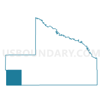
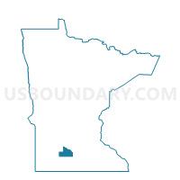
Stately Twp. Voting District, Brown County, Minnesota
About
Outline

Summary
| Unique Area Identifier | 601293 |
| Name | Stately Twp. Voting District |
| County | Brown County |
| State | Minnesota |
| Area (square miles) | 36.12 |
| Land Area (square miles) | 36.07 |
| Water Area (square miles) | 0.05 |
| % of Land Area | 99.86 |
| % of Water Area | 0.14 |
| Latitude of the Internal Point | 44.15925270 |
| Longtitude of the Internal Point | -95.03091820 |
Maps

Graphs
Select a template below for downloading or customizing gragh for Stately Twp. Voting District, Brown County, Minnesota


Neighbors
Neighoring Voting District (by Name) Neighboring Voting District on the Map
- Amboy Twp. Voting District, Cottonwood County, MN
- Bashaw Twp. Voting District, Brown County, MN
- Burnstown Twp. Voting District, Brown County, MN
- Delton Twp. Voting District, Cottonwood County, MN
- Germantown Twp. Voting District, Cottonwood County, MN
- North Star Twp. Voting District, Brown County, MN
- Selma Twp. Voting District, Cottonwood County, MN
Top 10 Neighboring County Subdivision (by Population) Neighboring County Subdivision on the Map
- North Star township, Brown County, MN (287)
- Burnstown township, Brown County, MN (268)
- Bashaw township, Brown County, MN (243)
- Germantown township, Cottonwood County, MN (207)
- Selma township, Cottonwood County, MN (193)
- Stately township, Brown County, MN (165)
- Amboy township, Cottonwood County, MN (164)
- Delton township, Cottonwood County, MN (123)
Top 10 Neighboring Unified School District (by Population) Neighboring Unified School District on the Map
- Red Rock Central School District, MN (3,434)
- Springfield Public School District, MN (3,379)
- Comfrey Public School District, MN (1,095)
Top 10 Neighboring State Legislative District Lower Chamber (by Population) Neighboring State Legislative District Lower Chamber on the Map
Top 10 Neighboring State Legislative District Upper Chamber (by Population) Neighboring State Legislative District Upper Chamber on the Map
Top 10 Neighboring 111th Congressional District (by Population) Neighboring 111th Congressional District on the Map
Top 10 Neighboring Census Tract (by Population) Neighboring Census Tract on the Map
- Census Tract 9606, Brown County, MN (3,221)
- Census Tract 2701, Cottonwood County, MN (2,897)
- Census Tract 2702, Cottonwood County, MN (2,407)